The Sacred Valley is one of my favorite areas in South-America. It’s not only due to its beautiful nature and ancient Inca ruins sprinkled everywhere but the valley has a certain sacred or magical feeling to it. To experience that, I ventured out and about and thanks to the advice of lots of people in the area, I found hikes, that weren’t crowded as they were not on the standard tourist itinerary. I had a hard time finding this information online, so I decided to write a description of the following hikes.
A few things to note:
- I am using maps.me in my screenshots. It’s proven to be more exact than Google. However, it is not perfect. I would say that the duration of the hikes that maps.me usually provides is overestimated and I sometimes took an hour less for a supposedly 3h-hike (that also depends on your fitness level).
- Also sometimes, the trail marked on maps.me is not 100% exact and correct. I found it a good indicator for an approximate direction. In case of doubt, always follow the trail, even if maps.me is telling you that you’re going off-trail (I was stuck in shrubs and sliding down hills on a hike because I just looked at the GPS location that I thought should overlap with the dotted trail on the app, instead of just looking out for the trail (which was 10m next to me -,-).
- Every time I am talking about a ‘collectivo’, I am referring to a minibus/van that drives around that you can catch from wherever along the road you are standing. Sometimes there are stops but usually people just wave them down to get on and shout ‘me quedo’ when they want to get off. They are mostly white in this area and rarely have signs on where they are going so make sure you verify with the driver when you get on. You pay when you get off (maybe ask a person sitting next to you how much to pay as you might get overcharged or ripped of otherwise).
Anywhere here we go
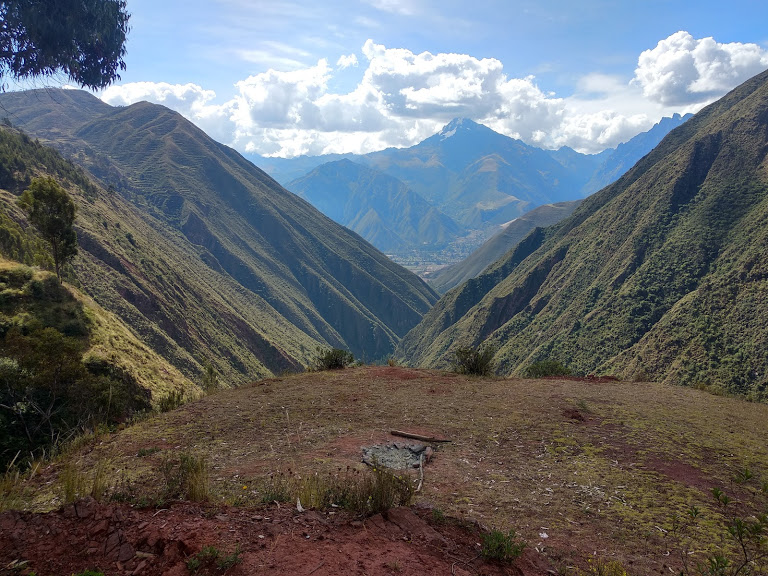
1) Chinchero to Urquillos – down a valley on an ancient Inca trail
Probably my favorite and also one that’s slightly known to people (I met about 5 people in the 3h on the hike, so not overly many).


This hike starts behind the market right next to the ruins of the town of Chinchero. It is well marked, there is a large sign saying that you’re walking on an ancient Inka trail. The trail goes through a valley, downhill into the small village of Urquillos. It’s well-marked, you can’t get lost. There will be one intersection whilst in the forest, where a small trail leads off to the right. If you take it, you get to a gorgeous lookout over the valley (and perfect meditation spot). The actual trail, however, continues going downhill. The detour should only take you an extra 10 min. The whole hike can take you 3-4 hours. Watch out when you get into Urquillos. You can walk on either road through the vast area (mostly through fields, not exactly a village) but make sure you take the road eventually that crosses the river, only one small road leads across it, so you can get to the main road to catch a collectivo from there.


How to get there:
From Cusco, take a collectivo towards Urubamba from the collectivo station on Avenue Grau. There are several companies, they will yell out ‘Urubamba’ when you walk down the street. The exact collectivo point is marked on maps.me
Get off at ‘Chinchero, about 30min from Cusco. Make sure you yell ‘me quedo’ or ‘baja’ when you get there so that the driver knows you want to get off (otherwise he might not stop!). Then walk towards the ruins, the trail starts to the left of them (see screenshot).
Once finished in Urquillos, cross the road and catch any collectivo back to Urubamba. From there you can return to Cusco by another collectivo or head to Ollantaytambo. If you want to head to Pisac, don’t cross the road, but stay on the side that you hit the road from Urquillos and take a collectivo the other direction.
Fares: Cusco-Chinchero 3-4 Soles (they might charge you 5)// Urquillos to Urubamba: around 1.20 Soles // Urubamba to Cusco 4-5 Soles
2) Salinas de Maras hike (salt mines)
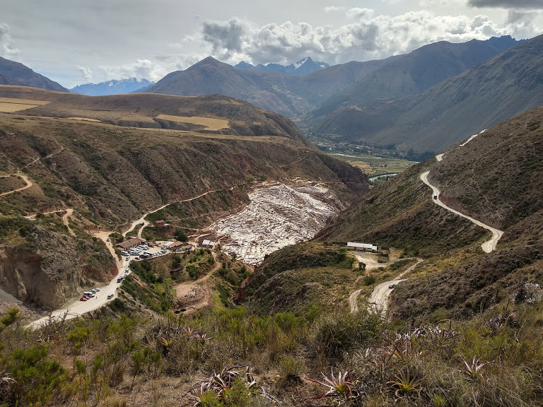
This is a hike that I basically ‘found’ on maps.me. I figured that instead of taking a taxi to the salt mines, I might as well walk. It was a great decision. You will hit the salt mines (10 soles entry, this is not included in the ‘bolleto turistico’ that gives access to a few sights in the area!).
Once you visited the salt mines you continue walking down the valley and end on the road close to Urubamba. It should take you about 4-5h including the visit to the salt mines
hike directions:
The hike starts at the bus stop with the road that leads to the town of Maras. You will walk on the paved road towards Maras for a few meters until you will find a small trail to your right in the fields. Follow the trail. It will go through the fields but is easy to find, especially when you check the GPS on maps.me
You will then have to cross the main road that leads to the salt mines and continue a few meters down the road on the other side.
Watch out: the next section of the trail goes a bit of the trail that is marked on maps.me, so when you’re walking on a trail and the GPS on maps.me tells you, you’re off, please trust the path and not the GPS. I ended up walking through the fields and also found my way but later realized it could’ve been much easier if I had simply looked out for the actual trail.
You will walk down the valley that will open up in front of you after a few minutes (you can spot the salt mines early on!). The trail will go all the way down into the valley, you cross a small stream, go up again and then enter the salt mines from above. You will enter through the parking lot (and they will find you and charge you, don’t worry ;))
You can then explore the salt mines. At the time I was visiting, you had to go out at the same spot where you entered, so I had to go back and then walk ‘above the mines’ to then descend the valley behind them.
There is only one trail though and you should easily find it. Continue walking down the valley until you walk through small villages and hit the main road (ending point from where you can take the collectivo back to Urubamba or hike partly along the river to Urubamba, which takes about an hour.
Alternatively, this is a great way to head to the hostel ‘Hostel and Campsite Mystical Adventures’, about halfway towards Urubamba. I stayed at this hostel for a few nights while exploring the Sacred Valley.


How to get there:
Take a collectivo from Cusco towards Urubamba (same as in hike 1)). Tell the driver you want to get off at ‘Maras’, the stop is called ‘paradero Maras-Moray‘ on google and basically on the road a few kilometers on the road towards Maras (the bus doesn’t go there)
Once you hike down the valley from the salt mines you will get to a small village called Tarabamba. You can take a collectivo from your side on the road to Urubamba and there switch to a collectivo back to Cusco.
collectivo fares: Cusco-Maras: around 4 Soles // Urubamba – Cusco: 4-5 Soles
hike 3) and 4) can be combined as they are in the same area (along the same main road). In that case I’d start with hike 4 as it’s long and you can see whether you have time left afterwards for hike.
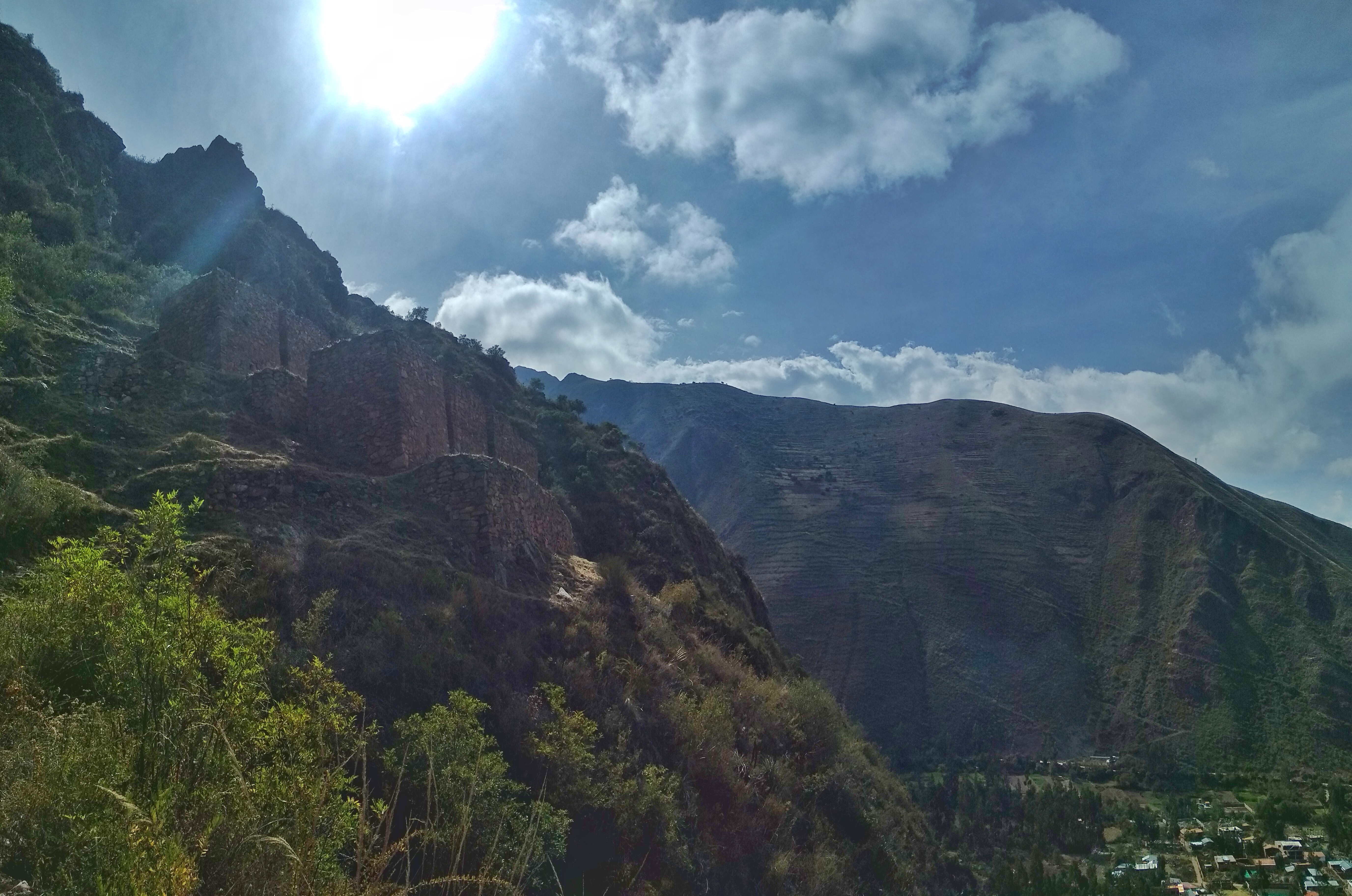
3) Naupa Iglesia (Choquequilla)
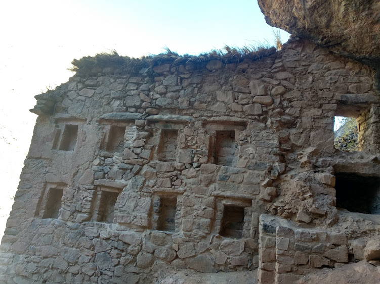
This is a short hike from Pachar. You have to walk along the main road but it’s not very busy and there is a little space next to the road where the cars drive on. And the scenery is beautiful as you’re walking into a valley. At a certain point, there is a construction site (it was there in winter 2019) and you can see some train tracks crossing the street. This is where you go off the main road and head to your right. There will be a small trail next to the train line. After around 10 minutes you will see the trail winding up the mountain and there will be a sign saying what things are forbidden to do in the area. You will walk up through some ruins to the actual sight. It is a sacred Inca site/temple overlooking the valley nestled into the side of a cave. Another spot to feel the ‘spirit’ of the Sacred Valley 🙂
Once done there you can walk back the same way to Pachar.
The river in Pachar is nice, so you can stop and rest a bit along the way and be surrounded by nature.
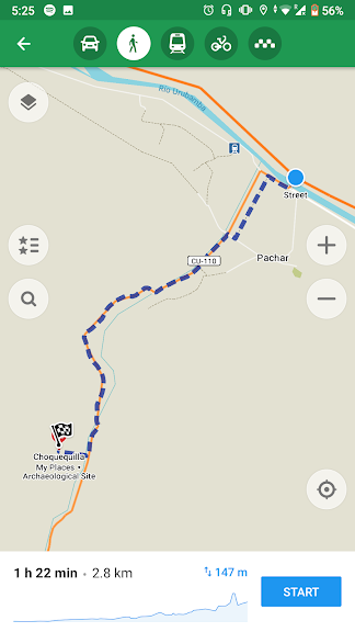
How to get there: Take a collectivo from Urubamba or Ollantaytambo. Price is around 2 Soles (from U.) or 1 Sol (from O.). The stop is next to a bridge, the ‘puente de Pajar’, that’s what you can tell the driver as you won’t necessarily see the village from the collectivo but rather just a bus stop area (the village is further away).
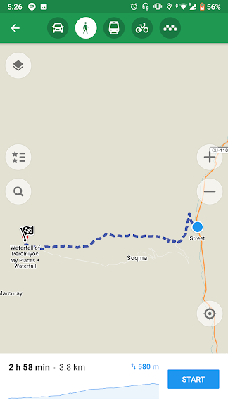
4) Perolniyoc Waterfall

An absolutely gorgeous hike to a waterfall. It is probably the most ‘challenging’ hike as it is the longest and also the hardest to get to and to do. Having said that, it’s definitely doable and I’d highly recommend it.
I had gotten slightly lost and have thus adapted the route for a more ‘foolproof’ method than maps.me makes it look like.
I recommend you start early in the day as the hike is 90% in an unshaded area and you don’t want to walk in the burning sun around noon.
The start of the hike is in the area where the collectivo should drop you off, at a bridge on the road that leads to the village of ‘Soqma’. As you will see on maps.me, shortly after walking a while on that road, the trail leads to the right up the mountain. Now, this is where I’m going to say I’d highly recommend you continue on the main road until you almost reach Soqma and then go on the trail that crosses the valley and goes onto the actual hiking trail on the other side.
I tried finding the first part of the trail, was on it and then suddenly off as the GPS on maps.me showed me I was off-trail when I was actually on a trail. That trail, however, didn’t lead up the mountain, so I ended up struggling to make my way through shrubs and bushes, climbing up the hill until I came onto a path that then easily led to the waterfall. In a way, once you’re on the right elevation, the hike is a breeze as there will only be one path. The challenge is getting up there. I tried an alternative route to go down the mountain on my way back by simply following a trail that leads downhill but I wouldn’t recommend that one either as it’s too steep (and not indicated on maps.me).
Again, you should have no problems if you simply walk on the main road for the first part and then switch to the hiking trail.
Alternatively, you could take a taxi to the waterfall. That would be around 40 Soles and you’d only have to walk up to the waterfall (10-15 minutes).
Again, don’t be discouraged. I have great memories from reaching the waterfall and once you’re on the trail at the right elevation, it’s a breeze to follow. You will pass through a valley with the small village of Soqma, along cornfields and small houses along the trail.
Hike back the exact same way you came from.
How to get there:
For that hike, take a collectivo to ‘Pachar’ from Urubamba or Ollantaytanbo (see hike 3)). There wait for another collectivo to take you to Puente ‘Jauja’ or something like that. It’s basically on the entrance to the village of Soqma, so you can also say that to the driver (or verify the name with the ladies selling food at the bus station). The price to go from Pachar to the starting point is 2 Soles
Try to avoid taxis, they will easily charge you 40 Soles.
I had trouble getting a ride back but I hailed down a car and paid them 5 Soles to take me back to Urubamba (hitchhiking in the valley is not free, the driver will ask you to pay when they pick you up).
5) Waterfalls in Arin

These are two gorgeous waterfalls, a short hike from the small town of Arin.
I recommend going on this hike if you’re staying close to Pisac or Urubamba. You can take a collectivo from both cities towards Arin. Tell the driver you want to go to the waterfalls and he will let you out at the right spot. You will be able to see the waterfalls as soon as you start walking through the town. maps.me has good trail signage. The hike shouldn’t take more than 40 min if you walk very slowly (or 20-30 if you’re fast). It’s a nice spot, not only for the waterfall but also for the view over Arin and the valley.

Additional small hikes, advisable when you’re in a certain area:
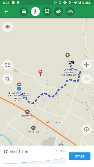
6) Querocancha
if you’re staying at the ‘Hostel and Campsite Mystical Adventures’ close to Urubamba:
There are some small Inka ruins up the mountain behind the hostel. You can ask the hostel owners to guide you to the start of the hike or walk on the ‘bigger road’ which is a small detour. Duration around 1.5h return from the hostel with time to take photos and rest
7) Side across the ruins in Ollantaytanbo:


Instead of only going to the famous Inca ruins, you can head up the mountain on the other side of the valley. It’s free and you will be able to have a look over the town and the ruins. Bonus point: this is the sunny side of the valley, so you’ll enjoy the warmth of the sunshine (if you have it) for much longer than on the other side (which will start not having sunlight just after 3 pm in winter).
The start is on the side of Ollantaytanbo (see screenshot, easy to find as the town is tiny). It won’t take you more than 30 minutes to walk to both sides but it’s a great spot to chill out for a bit
Some additional comments:
- Transportation through the valley can be done by collectivo (mini-van), moto-taxi (tuk-tuks) or also cars that might just pull over and tell you where they’re going.
When going by collectivo make sure you ask whether it is going all the way to where you want to go. When taking a moto-taxi or shared car always negotiate the price beforehand! You should never pay more than 5 Soles in the shared car. Motos usually go only small distances, I also wouldn’t pay more than 5 Soles (2 Soles for 5-10 minutes distance is a good guess)
Of course, there are also taxis, I usually don’t take them and in the Valley, they will usually charge you horrendous prices for taking you to the famous spots, which is why I’ve avoided them.
- Often, what’s marked as a ‘road’ on google maps or maps.me can turn out to be a dirt road or a bigger ‘trail’. Keep that in mind when reading the map while you’re hiking, looking out for a ‘road’.
- weather/sunshine: When I hiked in the valley in winter (June-August), the sun would set around 5:30 pm. However depending on which side of the valley you are, you might not have sunshine anymore at already around 3 pm. This is simply something to take into consideration. Also, starting to hike early is a good idea as the sun in the Valley (as most places in that altitude) is very strong. If you’re coming from Cusco, prepare yourself to take off some layers as the temperature in the valley is around 5 degrees warmer.
2 thoughts on “Hiking off the beaten track in the Sacred Valley – Inka ruins, ancient Inka trails, waterfalls and more”